Spherical coordinate system
In mathematics, a spherical coordinate system is a coordinate system for three-dimensional space where the position of a point is specified by three numbers: the radial distance of that point from a fixed origin, its inclination angle measured from a fixed zenith direction, and the azimuth angle of its orthogonal projection on a reference plane that passes through the origin and is orthogonal to the zenith, measured from a fixed reference direction on that plane. The inclination angle is often replaced by the elevation angle measured from the reference plane.
The radial distance is also called the radius or radial coordinate, and the inclination may be called colatitude, zenith angle, normal angle, or polar angle.
In geography and astronomy, the elevation and azimuth (or quantities very close to them) are called the latitude and longitude for geography and "declination" and "right ascension" for astronomy, respectively; and the radial distance is usually replaced by an altitude (measured from a central point or from a sea level surface).
The concept of spherical coordinates can be extended to higher dimensional spaces and are then referred to as hyperspherical coordinates.
Contents |
Definition
To define a spherical coordinate system, one must choose two orthogonal directions, the zenith and the azimuth reference, and an origin point in space. These choices determine a reference plane that contains the origin and is perpendicular to the zenith. The spherical coordinates of a point P are then defined as follows:
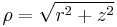
- the radius or radial distance is the Euclidean distance from the origin O to P.
- the inclination (or polar angle) is the angle between the zenith direction and the line segment OP.
- the azimuth (or azimuthal angle) is the signed angle measured from the azimuth reference direction to the orthogonal projection of the line segment OP on the reference plane.
The sign of the azimuth is determined by choosing what is a positive sense of turning about the zenith. This choice is arbitrary, and is part of the coordinate system's definition.
The elevation angle is 90 degrees (π/2 radians) minus the inclination angle.
If the inclination is zero or 180 degrees (π radians), the azimuth is arbitrary. If the radius is zero, both azimuth and inclination are arbitrary.
In linear algebra, the vector from the origin O to the point P is often called the position vector of P.
Conventions
Several different conventions exist for representing the three coordinates, and for the order in which they should be written. The use of (r, θ, φ) to denote, respectively, radial distance, inclination (or elevation), and azimuth, is common practice in physics, and is specified by ISO standard 31-11.
However, some authors (including mathematicians) use φ for inclination (or elevation) and θ for azimuth, which "provides a logical extension of the usual polar coordinates notation".[1] Some authors may also list the azimuth before the inclination (or elevation), and/or use ρ instead of r for radial distance. Some combinations of these choices result in a left-handed coordinate system. The standard convention (r, θ, φ) conflicts with the usual notation for the two-dimensional polar coordinates, where θ is often used for the azimuth. It may also conflict with the notation used for three-dimensional cylindrical coordinates. [1]
The angles are typically measured in degrees (°) or radians (rad), where 360° = 2π rad. Degrees are most common in geography, astronomy, and engineering, whereas radians are commonly used in mathematics and theoretical physics. The unit for radial distance is usually determined by the context.
When the system is used for physical three-space, it is customary to use positive sign for azimuth angles that are measured in the counter-clockwise sense from the reference direction on the reference plane, as seen from the zenith side of the plane. This convention is used, in particular, for geographical coordinates, where the "zenith" direction is north and positive azimuth (longitude) angles are measured eastwards from some prime meridian.
| coordinates | corresponding local geographical directions |
right/left-handed |
|---|---|---|
 |
 |
right |
 |
 |
right |
 |
 |
left |
Note: easting ( ), northing ( ), northing ( ), upwardness ( ), upwardness ( ). Local azimuth angle would be measured, e.g., counter-clockwise from ). Local azimuth angle would be measured, e.g., counter-clockwise from  to in the case of to in the case of  . . |
||
Unique coordinates
Any spherical coordinate triplet (r, θ, φ) specifies a single point of three-dimensional space. On the other hand, every point has infinitely many equivalent spherical coordinates. One can add or subtract any number of full turns to either angular measure without changing the angles themselves, and therefore without changing the point. It is also convenient, in many contexts, to allow negative radial distances, with the convention that (−r, θ, φ) is equivalent to (r, θ+180°, φ) for any r, θ, and φ. Moreover, (r, −θ, φ) is equivalent to(r, θ, φ+180°).
If it is necessary to define a unique set of spherical coordinates for each point, one may restrict their ranges. A common choice is:
- r ≥ 0
- 0° ≤ θ ≤ 180° (π rad)
- 0° ≤ φ < 360° (2π rad)
However, the azimuth φ is often restricted to the interval (−180°, +180°], or (−π, +π] in radians, instead of [0, 360°). This is the standard convention for geographic longitude.
The range [0°, 180°] for inclination is equivalent to [−90°, +90°] for elevation (latitude).
Even with these restrictions, if θ is zero or 180° (elevation is 90° or -90°) then the azimuth angle is arbitrary; and if r is zero, both azimuth and inclination/elevation are arbitrary. To make the coordinates unique one can use the convention that in these cases the arbitrary coordinates are zero.
Plotting
To plot a point from its spherical coordinates (r, θ, φ), where θ is inclination, move r units from the origin in the zenith direction, rotate by θ about the origin towards the azimuth reference direction, and rotate by φ about the zenith in the proper direction.
Applications
The geographic coordinate system uses the azimuth and elevation of the spherical coordinate system to express locations on Earth, calling them respectively longitude and latitude. Just as the two-dimensional Cartesian coordinate system is useful on the plane, a two-dimensional spherical coordinate system is useful on the surface of a sphere. In this system, the sphere is taken as a unit sphere, so the radius is unity and can generally be ignored. This simplification can also be very useful when dealing with objects such as rotational matrices.
Spherical coordinates are useful in analyzing systems that have some degree of symmetry about a point, such as volume integrals inside a sphere, the potential energy field surrounding a concentrated mass or charge, or global weather simulation in a planet's atmosphere. A sphere that has the Cartesian equation x2 + y2 + z2 = c2 has the simple equation r = c in spherical coordinates.
Two important partial differential equations that arise in many physical problems, Laplace's equation and the Helmholtz equation, allow a separation of variables in spherical coordinates. The angular portions of the solutions to such equations take the form of spherical harmonics.
Another application is ergonomic design, where r is the arm length of a stationary person and the angles describe the direction of the arm as it reaches out.
Three dimensional modeling of loudspeaker output patterns can be used to predict their performance. A number of polar plots are required, taken at a wide selection of frequencies, as the pattern changes greatly with frequency. Polar plots help to show that many loudspeakers tend toward omnidirectionality at lower frequencies.
The spherical coordinate system is also commonly used in 3D game development to rotate the camera around the player's position.
Coordinate system conversions
As the spherical coordinate system is only one of many three-dimensional coordinate systems, there exist equations for converting coordinates between the spherical coordinate system and others.
Cartesian coordinates
The spherical coordinates (ρ, φ, θ) of a point can be obtained from its Cartesian coordinates (x, y, z) by the formulae
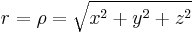
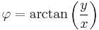
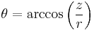
The inverse tangent denoted in φ = arctan(y/x) must be suitably defined, taking into account the correct quadrant of (x,y). See article atan2.
Alternatively, the conversion can be considered as two sequential rectangular to polar conversions: the first in the Cartesian x−y plane from (x,y) to (R,φ), where R is the projection of r onto the x−y plane, and the second in the Cartesian z-R plane from (z,R) to (r,θ). The correct quadrants for φ and θ are implied by the correctness of the planar rectangular to polar conversions.
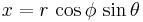
These formulae assume that the two systems have the same origin, that the spherical reference plane is the Cartesian x−y plane, that θ is inclination from the z direction, and that the azimuth angles are measured from the Cartesian x axis (so that the y axis has φ=+90°). If θ measures elevation from the reference plane instead of inclination from the zenith the arccos above becomes an arcsin, and the cos θ and sin θ below become switched.
Conversely, the Cartesian coordinates may be retrieved from the spherical coordinates (r, φ, θ), where r ∈ [0, ∞ ), φ ∈ [0, 2π ), θ ∈ [0, π ], by:


Geographic coordinates
To a first approximation, the geographic coordinate system uses elevation angle (latitude), usually denoted by δ or θ, in degrees north of the equator plane, in the range −90° ≤ δ ≤ 90°, instead of inclination. The azimuth angle (longitude) is measured in degrees east or west from some conventional reference meridian (most commonly that of the Greenwich Observatory), so its domain is −180° ≤ φ ≤ 180°. For positions on the Earth or other solid celestial body, the reference plane is usually taken to be the plane perpendicular to the axis of rotation. In astronomy one may measure latitude either from the celestial equator (defined by the Earth's rotation) or the plane of the ecliptic (defined by Earth's orbit around the sun) or, sometimes, the galactic equator (defined by the rotation of the galaxy).
The zenith angle or inclination, which is 90° minus the latitude and ranges from 0 to 180°, is called colatitude in geography.
Instead of the radial distance, geographers commonly use altitude above some reference surface, which may be the sea level or "mean" surface level for planets without liquid oceans. The radial distance r can be computed from the altitude by adding the mean radius of the planet's reference surface, which is approximately 6,360±11 km for Earth.
However, modern geographical coordinate systems are quite complex, and the positions implied by these simple formulae may be wrong by several kilometers. The precise standard meanings of latitude, longitude and altitude are currently defined by the World Geodetic System (WGS), and take into account the flattening of the Earth at the poles (about 21 km) and many other details.
Cylindrical coordinates
Cylindrical coordinates (r, φ, z) may be converted into spherical coordinates (ρ, θ, φ), by the formulas


Conversely, the spherical coordinates may be converted into cylindrical coordinates by the formulae


These formulae assume that the two systems have the same origin and same reference plane, measure the azimuth angle φ in the same sense from the same axis, and that the spherical angle θ is inclination from the cylindrical z axis.
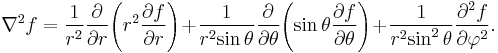
Integration and differentiation in spherical coordinates
The following equations assume that θ is inclination from the normal axis:
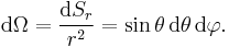
The line element for an infinitesimal displacement from  to
to  is
is

where  are the local orthogonal unit vectors in the directions of increasing
  , respectively.
The surface element spanning from  to
to  and
and  to
to  on a spherical surface at (constant) radius
  is
is

Thus the differential solid angle is
The surface element in a surface of polar angle constant (a cone with vertex the origin) is

The surface element in a surface of azimuth constant (a vertical half-plane) is

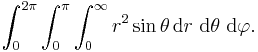
The volume element spanning from to  , to , and to is

Therefore every point in R3 can be integrated by the triple integral
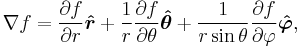
The del operator in this system is not defined, and so the gradient, divergence and curl must be defined explicitly:


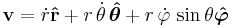
Kinematics
In spherical coordinates the position of a point is written,

its velocity is then,
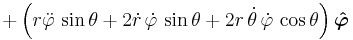
and its acceleration is,
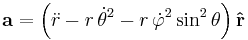
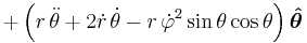
In the case of a constant φ this reduces to vector calculus in polar coordinates.
See also
- Celestial coordinate system
- Del in cylindrical and spherical coordinates
- Euler angles
- Gimbal lock
- Hypersphere
- Jacobian matrix and determinant
- List of canonical coordinate transformations
- Sphere
- Spherical harmonic
- Theodolite
- Vector fields in cylindrical and spherical coordinates
- Yaw, pitch and roll
Notes
- ^ a b Eric W. Weisstein (2005-10-26). "Spherical Coordinates". MathWorld. http://mathworld.wolfram.com/SphericalCoordinates.html. Retrieved 2010-01-15.
Bibliography
- Morse PM, Feshbach H (1953). Methods of Theoretical Physics, Part I. New York: McGraw-Hill. pp. 658. ISBN 0-07-043316-X. LCCN 52-11515.
- Margenau H, Murphy GM (1956). The Mathematics of Physics and Chemistry. New York: D. van Nostrand. pp. 177–178. LCCN 55-10911.
- Korn GA, Korn TM (1961). Mathematical Handbook for Scientists and Engineers. New York: McGraw-Hill. pp. 174–175. LCCN 59-14456, ASIN B0000CKZX7.
- Sauer R, Szabó I (1967). Mathematische Hilfsmittel des Ingenieurs. New York: Springer Verlag. pp. 95–96. LCCN 67-25285.
- Moon P, Spencer DE (1988). "Spherical Coordinates (r, θ, ψ)". Field Theory Handbook, Including Coordinate Systems, Differential Equations, and Their Solutions (corrected 2nd ed., 3rd print ed. ed.). New York: Springer-Verlag. pp. 24–27 (Table 1.05). ISBN 978-0387184302.
External links
- MathWorld description of spherical coordinates
- Coordinate Converter - converts between polar, Cartesian and spherical coordinates
- Spherical Coordinates Animations illustrating spherical coordinates by Frank Wattenberg
- Conventions for Spherical Coordinates Description of the different conventions in use for naming components of spherical coordinates, along with a proposal for standardizing this.
|
||||||||